Port Royal Sound
The LowCountry Institute gives permission for educators and teachers to utilize this presentation for educational purposes.
![]() What Makes Port Royal Sound Unique?
What Makes Port Royal Sound Unique?
Here are some tips:
-
To open the presentation, click the link above. To save the presentation, select "Save As" and save it to your computer.
-
There are notes that accompany each slide that explain concepts in further detail. Mouse over the orange icon in the upper left corner of each slide to see the notes. Or, click the icon on the lower left corner of the window that looks like a dialogue balloon. From there, you will be able to view and print all of the slide notes.
- The presentation is in adobe pdf format. Click "view > full screen mode" to view like a powerpoint presentation.
Port Royal Sound is a marriage of ocean and land, a relationship created by the combination of rising sea level, exceptionally high tides, and its unique geology. The synergistic combination of these three factors has produced a marine environment that is one of North America’s overlooked ecological jewels. As residents of the Lowcountry, it is our responsibility to understand and protect it.
The Port Royal Sound system is unique compared to other coastal areas in North America because it is a large embayment dominated by expansive salt marshes and an area with high salinity water. An embayment was created when rising sea levels submerged valleys along the coast. The net result was and is that Port Royal Sound represents a marine habitat that extends inland for nearly 20 miles. Half of Beaufort County is actually under marine waters.
Port Royal Sound has these conditions because of three factors: (1) It does not have any freshwater rivers of significant size entering it; (2) It has an exceptionally high tidal amplitude; and (3) Its low lying topography was submerged by rising sea level.

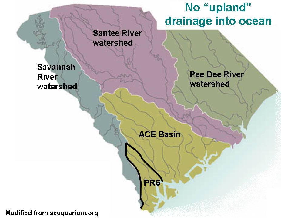
Port Royal Sound – Figure 1. Port Royal Sound watershed outlined in black. Note that there are no rivers feeding into PRS that originate in the mountains.
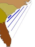
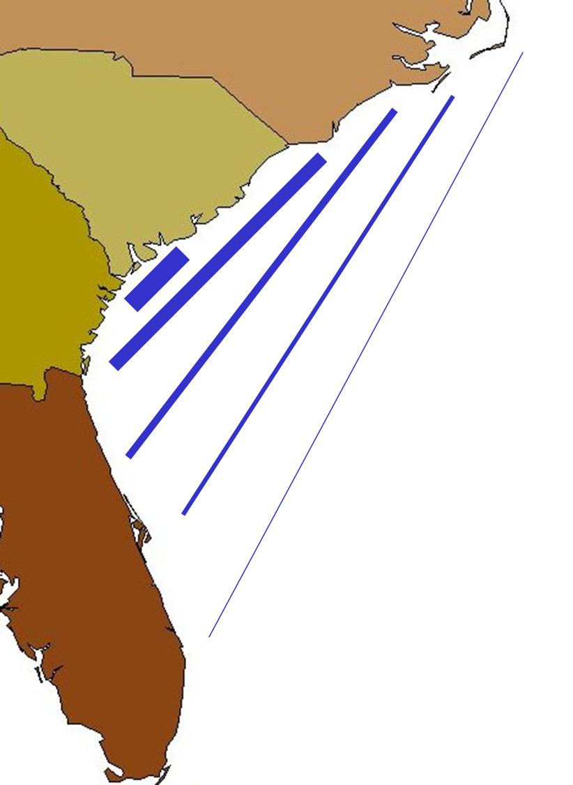
South Atlantic Bight – Figure 2. Tidal amplitude is very high in PRS because of coastal geography. The same volume of water is pushed into a smaller and smaller area as the tide rises.
Former Coastline – Figure 3. Sea level is rising – approximately 13,000 years ago, our shoreline was nearly 60 miles off our current coast.
The absence of freshwater rivers influences this coastal area in two ways. First, there was no source of sediment to fill in low-lying areas as the sea level rose. This lack of sediment migration explains why sections of the Sound are over 40 feet deep and most of its tidal creeks are 10 or more feet deep. Second, the lack of freshwater resulted in there being little or no brackish marsh in the Port Royal Sound system. Since the sound has an average tidal amplitude of 8.5 feet and little freshwater inflow, the net result is that the sound’s salinity is influenced primarily by tidal waters from the ocean rather than freshwater from the upland. The lack of brackish marsh illustrates how limited this freshwater input is.
The impact of a rising sea level on the region is obvious - half of Beaufort County is now at or below sea level. Even though the maps show names like the Broad River and the May River, these “rivers” are actually salt water “fingers” extending inland because most of their flow comes from the ocean in the form of tides, rather than from the uplands in the form of runoff.
The net result is that Spartina alterniflora and salt marshes dominate the local landscape and extend far inland. Not surprisingly, half of all South Carolina’s salt marsh occurs in Beaufort County. The exceptionally large tidal amplitude maintains a high flow rate to flush them out and keep them healthy.
The Port Royal Sound system does receive some freshwater runoff from inland areas including adjacent sections of Hampton and Jasper counties. The importance of this freshwater runoff is significant to certain marine species. This relationship is best illustrated during drought periods when blue crab and shrimp production decline dramatically. Female blue crabs do not breed in high salinity waters and therefore are absent during severe droughts when salinity of Port Royal Sound’s salt marshes may even exceed the salinity of the ocean (because of evaporation). During severe droughts, shrimp catch is lowered due to changes in distribution patterns of these crustaceans in response to higher salinity levels.
What makes Port Royal Sound different from all other coastal areas?
1. No Real Rivers Are Present:
Unlike other coastal areas it does not receive freshwater from a river. The named “rivers” are actually large salt water tidal waterways. The Broad, Colleton and May Rivers are actually large salt water tidal waterways with flow from the ocean rather than from inland areas. The only two freshwater inputs are the New and Coosawhatchie Rivers, but they drain relatively small areas of uplands and therefore contribute relatively small volumes of freshwater.
2. Rising Sea Level Has Created a Flooded Landscape:
Rising sea level has slowly flooded the original coastal landscape transforming former valleys into deep tidal creeks and hilltops into islands surrounded by salt marsh. Local tidal creeks and waterways are deep because there are no rivers emptying sediment into this system. In contrast, coastal areas with major freshwater rivers have remained shallow as sea level rose because of continued accumulation of sediment originating from these rivers.
3. Exceptionally High Tides Create Wide Expanses of Salt Marsh:
Port Royal Sound experiences the highest tides along the Atlantic coast south of Maine. The tidal amplitude (difference between high and low tide) ranges from 6 feet during neap tides to over 10 feet during Spring tides. These exceptionally high tides are created because of the concave curvature of the coastline between North Carolina and Florida. Gravity from the moon pulls up a bulge of water on the ocean’s surface. As the earth rotates eastward through this bulge, a large amount of water is pushed up against the continent, but the coastline’s curvature causes this water to be focused at the vertex of the curve, which happens to be the mouth of Port Royal Sound.
These exceptionally high tides are responsible for Beaufort County having at least 50% of South Carolina’s salt marsh. Spartina alterniflora is the only species of plant that grows in salt water in temperate North America. It thrives where it is submerged at least once a day by salt water, but its roots are also exposed to the air daily during low tides. The lack of freshwater and the large areas of submerged coastal terrain in Beaufort County combine to create expansive marshes of Spartina alterniflora.